|
|---|
 |
|||
|---|---|---|---|
|
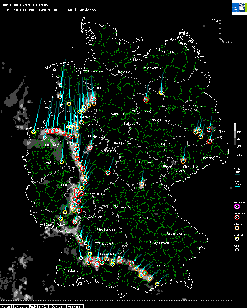
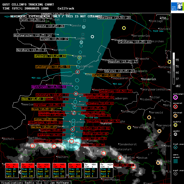
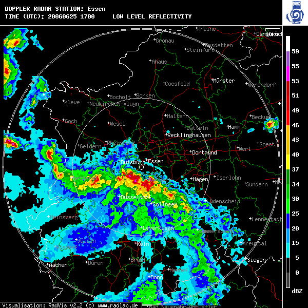
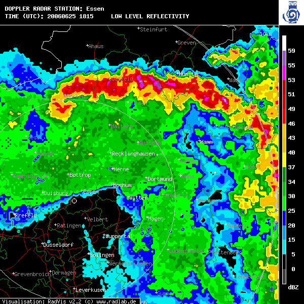
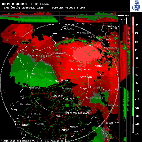
MOS on moving objects
(click on the maps for a larger version)
Thunderstorm warning for the city of Haltern and individual cell information, same time as figure above. These are
automatically generated texts produced by the prototype based on the forecasts. ******************************************************************************* SEVERE SHOWER/THUNDERSTORM WARNING FOR Haltern ISSUED at 18.00 UTC 25.06.2006 ******************************************************************************* VALID from 18.00 until 18.15 A severe thunderstorm was located about 7 km N of Haltern, reaching Haltern at about 18.00 UTC This thunderstorm is capable of producing... ...HEAVY PRECIPITATION OF ABOUT 30 L/QM WITHIN SHORT TIME ...LARGE HAIL OF ABOUT 3 CM IN DIAMETER ...STRONG GUSTS OF ABOUT 100 KM/H ...only occasional lightning REMEMBER: Heavy rainfalls of 30 l/qm can cause local flash floods with enhanced threat in lower areas of hilly terrain. Large Hail up to 3 cm in diameter can brake windows, damage cars Strong wind gusts of 100 km/h can uproot trees and lift loose items. If you are located within the warned area... secure loose items firmly and seek shelter immediately when the storm aproaches. Stay away from windows. If you are not able to seek shelter avoid open terrain and stay away from tall objects like trees or power lines. Beware of flying objects. = ******************************************************************************* ******************************************************************************* SEVERE THUNDERSTORM CELL INFORMATION ISSUED at 18.00 UTC 25.06.2006 ID 200606251800 3 51.8365 7.3336 NEAREST RADAR STATION ess ******************************************************************************* VALID immediately A severe thunderstorm has been detected in county Coesfeld... ...near Dernekamp or about 11 km S of Nottuln or about 23 km N of Waltrop ...moving to the N with 50 km/h This severe thunderstorm is capable of producing ...HEAVY PRECIPITATION OF ABOUT 25 L/QM WITHIN SHORT TIME ...LARGE HAIL OF ABOUT 2 CM IN DIAMETER ...STRONG GUSTS OF ABOUT 90 KM/H ...only occasional lightning The following counties may be affected with this storm within two hours: Coesfeld at 18.00 UTC with PROB 94 Steinfurt at 18.30 UTC with PROB 79 Emsland at 19.05 UTC with PROB 58 Borken at 18.35 UTC with PROB 47 Grafschaft Bentheim at 19.00 UTC with PROB 35 And the following locations may be affected within two hours: Nordhorn at 19.20 UTC with PROB 9 Coesfeld at 18.25 UTC with PROB 3 Dülmen at 18.00 UTC with PROB 75 Lingen at 19.30 UTC with PROB 37 Meppen at 19.50 UTC with PROB 25 Steinfurt at 18.45 UTC with PROB 73 Rheine at 19.00 UTC with PROB 48 ... Haltern at 18.40 UTC with PROB 48 ... Forecast data fp lat lon c dd ff dde ffe pcp hal gst lgt **** ******* ******* * *** *** *** *** *** *** *** *** +000 51.8365 7.3336 4 198 50 0 0 25 2 90 0 +005 51.8567 7.3358 4 184 27 8 8 25 2 115 158 +010 51.8800 7.3384 4 184 31 16 16 27 4 106 123 +015 51.9159 7.3405 4 182 47 24 24 26 3 114 135 +020 51.9506 7.3424 4 182 46 32 32 27 4 108 152 +025 51.9723 7.3443 4 183 29 40 40 27 2 109 156 +030 52.0250 7.3458 4 181 70 48 48 26 3 107 138 +035 52.0632 7.3479 4 182 51 56 56 23 3 117 153 +040 52.0979 7.3539 4 186 46 64 64 24 3 115 133 +045 52.1524 7.3554 4 181 72 72 72 24 4 113 131 +050 52.1930 7.3612 5 185 54 80 80 28 5 138 174 +055 52.2403 7.3639 5 182 63 88 88 32 4 137 167 +060 52.2960 7.3655 4 181 74 96 96 24 2 120 132 +065 52.3303 7.3684 3 183 45 104 104 18 2 103 86 +070 52.3631 7.3722 3 184 43 112 112 19 2 107 114 +075 52.3914 7.3779 3 187 38 120 120 22 1 108 115 +080 52.4293 7.3844 2 186 50 128 128 15 1 92 64 +085 52.4718 7.3893 2 184 56 136 136 15 2 79 52 +090 52.4956 7.3913 1 183 31 144 144 10 0 73 4 +095 52.5217 7.3981 1 189 35 152 152 11 0 63 29 +100 52.5485 7.4043 1 188 36 160 160 12 0 64 16 +105 52.5983 7.4086 1 183 66 168 168 11 1 79 16 +110 52.6422 7.4137 1 184 58 176 176 10 0 67 4 +115 52.6841 7.4173 1 183 56 184 184 8 0 63 14 +120 52.7364 7.4233 1 184 70 192 192 12 0 60 9 **** ******* ******* * *** *** *** *** *** *** *** *** = *******************************************************************************
|
|
|||||||||||||||||||||||||||||||||||||||||||||||||||||||||||||||||||||||||||||||||||||||||||||||||||||||||||||||||||||||||||||||||||||||
 |
|||
|---|---|---|---|